Lake Mackenzie (Red River Basin)
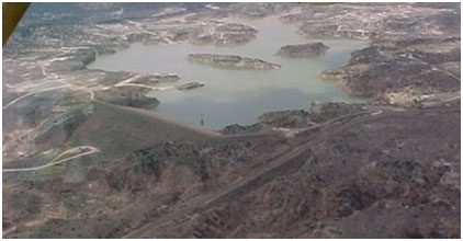 Lake Mackenzie, also known as Mackenzie Reservoir, is located about nine miles northwest of Silverton in Briscoe County, Texas on Tule Creek, a tributary of the Red River. The reservoir extends into Swisher County and has a drainage area of 188 square miles. It is operated by Mackenzie Municipal Water Authority for water supply to the member cities of Floydada, Lockney, Silverton, and Tulia. Designed by Freese, Nichols and Endress, construction of the dam began in September 1972 and was completed in April 1974. Deliberate impoundment started April 1974. The dam is rolled earthfill embankment with the top at elevation, 3,126 feet above mean sea level. The uncontrolled emergency spillway is located to the right end of the dam and is excavated on the natural ground with the crest at elevation, 3,110 feet above mean sea level. The uncontrolled service spillway is located on the right abutment of the dam and is consisted of concrete ogee, discharge chute and flip bucket. The crest of service spillway is at elevation, 3,100 feet above mean sea level. The lake has a storage capacity of 47,151 acre-feet encompassing a surface area of 910 acres at the conservation pool elevation, 3,100 feet above mean sea level.